
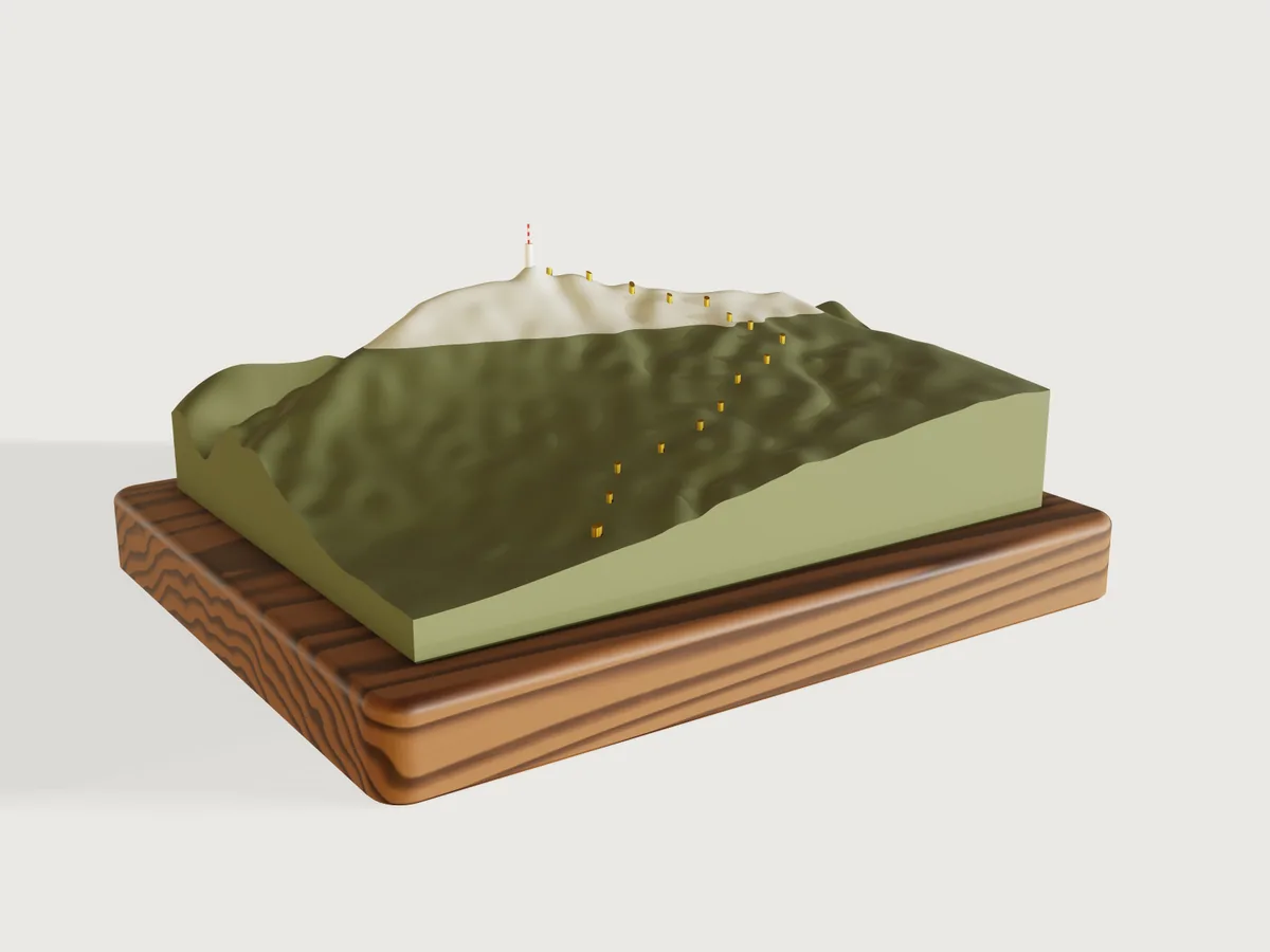
Mont Ventoux, the Giant of Provence, at 1:70 000, with the climb from Bédoin that ended stage 7 of the
Tour de France Femmes 2026: a relief 3D-printed in two colours as the mountain looks, forest green up to
Chalet Reynard and pale limestone above, sixteen brass pins at the climb's kilometres, the summit tower in
white and red, on a walnut base. One parameter turns the same terrain into a stack of laser-cut contour
layers. It is the one example built from outside data: make.py reads SRTM's elevation and IGN's road
and tower and writes them into steps as numbers; everything that is geometry (the scales, the terrain
surface, the solid, the pins' placement, the colour change, the tower's fit, the layers, every check) is
done by 3DCraft.
What it shows
- A terrain from a grid of heights. One
sketch.splineper column of the 37 × 29 grid, withlive: true: its through-points are expressions (1910 m * vertical_scaleat the summit), fitted again at every regeneration, so the exaggeration is a parameter. Each column is closed down to sea level by asketch.polyline, andfeature.loftof the 37 columns is the solid at once: no boolean. - Data in the model's own frame. Positions are metres from the grid's origin in Lambert-93 divided by
map_scale; heights are metres timesvertical_scale.make.pywrites numbers only. - Pins placed by the terrain.
sketch.circleat each kilometre in one sketch,feature.extrude, afeature.transformcopy of the terrain raised by the pins' protrusion andfeature.booleanintersect: each pin ends 2 mm above the ground under it.feature.offsetProfilegives the holes their clearance. - Two colours, split at a height. Two blocks meeting at the forest's edge, each drilled with
feature.extrudeandcut, then each intersected with the terrain (keepTool): the forested slopes and the bald summit are two bodies that meet on one flat face, where the printer changes filament.feature.chamferbreaks the bottom edge for the first layer. - A landmark fitted to the ground. The summit tower is a
feature.revolveof one polyline about its own axis line;feature.booleansubtractof the terrain (keepTool) shapes its foot to the summit;face.appearancepaints every other band of the mast red. - Two products from one terrain. A choice parameter and
whenon 47 steps (44 features, 3 assertions); in the laser-cut productvertical_scaleisif(product == 2, sheet_thickness / contour_interval, ...), so the 3 mm sheet sets the exaggeration. Slabs (feature.block, copied byfeature.transformfrom a white and a grey one) intersected with the terrain make one body per contour layer, andfile.exportwithfaceandorigin: modelwrites each layer's underside as a DXF of its own, all in the map's frame. - Woodwork.
feature.filleton the base's corners and, chained, round its top edge;feature.chamfer, chained, breaks the bottom edge. - Materials and checks.
body.appearancewith every field set,material.preset(walnut, a brass tuned from steel),body.material,assert.addwith volume, box and count measures on the terrain and on two thinfeature.cylinderprobes cut by it, andfeature.visibleto hide the source terrain and the probes.
The real thing
-
The climb. Tour de France Femmes avec Zwift 2026, stage 7, La Voulte-sur-Rhône to Mont Ventoux, 7 August 2026: "Mont Ventoux (15.7km at 8.8%)", climbed from Bédoin, and the first finish of the women's race on the Giant of Provence (commentary, stage report). IGN's road, the D974, measured back 15.7 km from its highest point (1897.9 m, at the finish beside the summit tower) starts the climb at 544.4 m: to that highest point it climbs 1353.5 m, 8.6 %; to the summit's 1910 m it is 1366 m, 8.7 %, where the race gives 8.8 % by its own measure. The checks compare the relief with the summit, 1910 m.
-
Data. Elevation: SRTM, 1 arc-second, from the Mapzen terrain tile N44E005; road and tower: IGN BD TOPO (sources, dates and licences in
data/SOURCES.md). The grid has nodes every 350 m in Lambert-93 (EPSG:2154), 12.6 × 9.8 km, one node on SRTM's highest cell. Each node is the elevation smoothed by a Gaussian of σ = 87.5 m, so that ravines narrower than the grid do not alias into bumps; the summit node alone keeps SRTM's 1910 m (smoothed it would be 1874 m). SRTM's heights are good to 6.2 m over Eurasia at 90 % (Rodríguez, Morris and Belz, A Global Assessment of the SRTM Performance, PE&RS 72(3), 2006); the mission asked for 16 m, which is what the start's check allows.make.py fetchalso writes the climb's kilometres (data/kilometres.csv). -
Scales. 1:70 000 in plan (a node every 5 mm: the relief is 180 × 140 mm) and, printed, 2.1 times that vertically: the summit stands 57.3 mm above the relief's underside, which is sea level.
-
The printed relief. Printed flat on its underside, 0.2 mm layers, from
exports/ventoux-relief.3mf(meshed within 0.2 mm), in Bambu Lab PLA Matte: Dark Green up to the forest's edge and Bone White above, one filament change at 42.57 mm (at 2.1×). The colours are filamentcolors.xyz's measurements of the printed filaments (swatches 4360, #656A4D, and 4885, #D4D1C3), drawn matte and not metallic; density 1.31 g/cm³ (Bambu Lab's data sheet, ISO 1183). The 3MF holds the two colours as two separate objects (F-045), and a slicer would put the bald summit down on the bed on its own: assemble them into one object with two parts before slicing, and give each part its filament. The forest's edge is Chalet Reynard, 6.2 km before the top, "which marks the moment on which the Mont Ventoux road quits the forest and enters a moon-like, fully exposed landscape" (the stage report): IGN's road is at 1419.1 m there. Solid it would weigh 995 g of green and 21 g of white; three walls and a sparse infill take a fraction of that. The bottom edge is chamfered 1 mm against the first layer's squash. The sixteen holes are blind, printed vertically down to a 3 mm floor, 0.1 mm wider all round than the pins: Ø 1.7 mm for 1.5 mm brass rod (CW508L), Ø 2.7 mm for the 2.5 mm rod at the start of the climb. Ream them to size (printed holes come out small), push each rod in until it bottoms, glue it and cut it 2 mm proud of the ground; the model's pin tops follow the slope, a cut rod is square. -
The summit tower. A symbol at ten times the map's scale, from IGN's building: Ø 14.4 m (its 162.3 m² footprint), 44.8 m tall on the ground at 1893.5 m, its antenna's top at 1975.5 m. On the model it is Ø 2.05 mm and 11.7 mm tall with a Ø 0.6 mm mast, too fine for the FDM print: it is printed on its own in resin (
exports/ventoux-tower.3mf), painted white with three red bands and glued on the summit, its foot shaped to the ground. -
The walnut base. 210 × 170 × 22 mm, the grain along its 210 mm length, a 15 mm border round the relief, corners rounded 8 mm, the top edge rounded over 3 mm with a router, the bottom edge broken 1 mm; oiled. The relief is glued on.
-
The laser-cut layers (Product: Laser-cut layers). One 3 mm sheet per contour interval from sea level, so the sheet sets the exaggeration: 2.1× at 100 m, 1.4× at 150 m, 1.05× at 200 m. At 100 m there are 17 outlines and 20 sheets: layer 1 is the whole map, sea level to 400 m, four sheets (the lowest ground is at 338 m); layers 2 to 17 start at 400 m to 1900 m, the last a cap under the summit tower. Cut from 3 mm cast acrylic, white and pale grey in turn, from
exports/layers/ventoux-layer-01.dxfto-17.dxf. Each file is one layer's underside in the map's frame, seen from below (its y runs south). The outlines are the parts' edges: offset them by half the kerf, about 0.08 mm for the 0.15 mm kerf of 3 mm cast acrylic. To register the stack, load each file with the next one (they share one origin), mirror both with the same mirror (y → −y, about the shared origin, not each about its own centre), then cut the layer and engrave the next layer's outline on its top face as the glue guide, the trade's usual way; do not turn the pieces over; two dowel holes drilled through the four full sheets of layer 1 and into the base hold the bottom true. The model shows each layer as the slice of the terrain it stands for; cut from flat sheet, the stack steps at every contour (see the platform notes). -
Laser pieces to leave out. The rule: leave out every island narrower than the 3 mm sheet and do not cut holes narrower than it; keep the rest. Measured on the DXFs at the defaults of each interval (width × length of the piece):
Interval Leave out Do not cut Keep (fragile) 100 m layer 5 (700 m): a 1.5 × 6.6 mm sliver on the map's north edge and a 1.7 × 2.8 mm island (a knoll of 689 m that the spline lifts over 700 m); layer 9 (1100 m): 1.4 × 2.3 mm; layer 15 (1700 m): 2.5 × 5.0 mm; layer 17 (1900 m): the 2.2 × 2.7 mm summit cap, glue the tower on layer 16 layer 10 (1200 m): hole 1.3 × 2.4 mm layer 5: 3.1 × 4.1 mm (a knoll of 698 m, lifted likewise); layer 16: 3.4 × 5.5 mm 150 m layer 6 (1050 m): slivers 0.8 × 12.8 and 0.1 × 3.1 mm layer 7 (1200 m): hole 1.3 × 2.4 mm layer 11: 3.4 × 5.6 mm 200 m layer 6 (1200 m): hole 1.3 × 2.4 mm layer 9: 3.4 × 5.7 mm Narrow notches in an outline are cut as drawn; the kerf rounds them.
-
Simplified, or left out.
- The road is marked by its kilometre pins, not drawn between them (see the platform notes).
- Kilometres are measured along IGN's road with its rise, from the climb's start; they are not the D974's own kilometre stones, which count from Bédoin.
- The grid holds what 350 m apart can: valleys and ridges narrower than about 700 m are rounded. Below the summit ridge the relief runs under the road: the km 15 pin's top stands 56.12 mm high, ground at 1804 m where IGN's road is at 1831 m.
- The forest's edge is drawn level at Chalet Reynard's height; on the mountain it climbs and falls with exposure.
- No lettering on the base (a text costs a font of 332 KB in the file, F-037).
Parameters
| Parameter | Range | Default |
|---|---|---|
| Vertical exaggeration (printed relief) | 1 to 3, in steps of 0.1 | 2.1 |
| Contour interval (laser-cut layers, one 3 mm sheet each) | 100, 150 or 200 m | 100 m |
| Product | Printed relief, Laser-cut layers | Printed relief |
Checks
- Terrain volume from the data's mean height. The terrain from sea level up must hold the map's area times the data's mean height (1026.9 m by the trapezoidal rule over the grid), times the vertical scale, within 0.1 %, the room between straight lines and a cubic surface through the same nodes: 776 585.5 mm³ against 776 336.4 mm³ at the defaults, a mean height of 1027.2 m.
- Summit at the data's height. A probe at the summit node reaches 1910 m within 2 m: its top is 57.302 mm, 1910.1 m.
- Start of the climb at the road's height. A probe at the climb's start reaches IGN's 544.4 m within SRTM's 16 m: its top is 16.221 mm, 540.7 m. With the summit, the climb on the relief is 1369 m against 1366 m from IGN's start to the summit.
- Sixteen kilometre pins (km 0 to 15) and a hole for every pin, through both colours: 16 holes in the forested slopes and, for km 10 to 15 above the forest's edge, 6 more through the bald summit.
- One layer per contour (laser-cut layers): as many contour layers as the interval gives up to the summit, 17 at 100 m.
craft3d-cli check-range proves them at 18 points: the defaults, the eight corners of the parameter
box, each product and eight random points; it does not try every value.
Data and licences
Elevation: SRTM data courtesy of the U.S. Geological Survey, through the Mapzen terrain tiles (the
attribution the tiles ask for is in data/SOURCES.md). Road, its kilometres and the tower: IGN – BD TOPO®, Géoplateforme,
Licence Ouverte / Open Licence 2.0, extracted 2026-11-07.
The README in the model's repository has the rest (Files, Rebuild, Difficulty, Platform notes, Licence): the whole README on GitHub.